You are currently viewing only those items made visible to the public. Click here to sign in and view the full catalogue.
| AVAILABILITY | Upon request |
|---|---|
| TRAINING | Training is required to use this item and we can arrange this if needed. |
| CUSTODIAN | Professor Jim Chandler |
|---|---|
| ADDITIONAL CONTACT | Nicholas Rodgers |
| Enquire about this item | |
| SITE | West Park |
Description
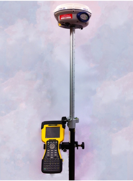
Used with the Trimble TSC2 Windows-based Controller (pictured), the Trimble R6 gives surveyors the latest in GNSS technology in a user-friendly system that is lightweight, rugged, and cable free.
The receiver itself combines a highly integrated and advanced GPS receiver, precision antenna, long-life battery and integrated communications in a rugged and reliable body Choose the type of communications to best fit how your crews work.
The Trimble R6 receiver delivers the accuracy and reliability required for precision surveying with superior tracking and RTK performance With GPS L2C included, and the GLONASS option, you can track more satellites and measure more successfully in challenging environments L2C provides more than justadditional signals The advanced signal structure provides better strength for more reliable satellite tracking.
Specification
//**Measurements:**//
- Trimble R-Track technology
- Advanced Trimble Maxwell 6 Custom Survey GNSS chip with 72 channels
- High precision multiple correlator for GNSS pseudorange measurements
- Unfiltered, unsmoothed pseudorange measurements data for low noise, low multipath error, low time domain correlation and high dynamic response
- Very low noise GNSS carrier phase measurements with <1 mm precision in a 1 Hz bandwidth
- Signal-to-Noise ratios reported in dB-Hz
- Proven Trimble low elevation tracking technology
- Satellite signals tracked simultaneously:
- GPS: L1C/A, L2C, L2E (Trimble method for tracking L2P)
- GLONASS: L1C/A, L1P, L2C/A (GLONASS M only), L2P
- SBAS: L1C/A
//**Code differential GNSS positioning:**//
| Horizontal | 0.25 m + 1 ppm RMS |
| Vertical | 0.50 m + 1 ppm RMS |
| WAAS differential positioning accuracy | typically <5 m 3DRMS |
\\ //**Static and FastStatic GNSS surveying:**//
| Horizontal | 3 mm + 0.1 ppm RMS |
| Vertical | 3.5 mm + 0.4 ppm RMS |
\\ //**Kinematic surveying:**//
| Horizontal | 10 mm + 1 ppm RMS |
| Vertical | 20 mm + 1 ppm RMS |
| Initialization time | typically <25 seconds |
| Initialization reliability | typically >99.9% |
\\ //**Hardware:**//
| Dimensions (W×H) | 19 cm × 10.9 cm (7.5 in x 4.3 in) including connectors |
| Weight | 1.34 kg (2.95 lb) with internal battery, internal radio, standard UHF antenna. 3.70 kg (8.16 lb) entire RTK rover including batteries, range pole, controller and bracket. |
| Temperature | Operating: –40 °C to +65 °C (–40 °F to +149 °F) Storage: –40 °C to +75 °C (–40 °F to +167 °F) |
| Humidity | 100%, condensing |
| Water/dustproof | IP67 dustproof, protected from temporary immersion to depth of 1 m (3.28 ft) |
| Shock and vibration | Tested and meets the following environmental standards: Non-operating: Designed to survive a 2 m (6.6 ft) pole drop onto concrete. Operating: to 40 G, 10 msec, sawtooth |
| Vibration | MIL-STD-810F, FIG.514.5C-1 |
\\ //**Electrical:**//
- Power 11 to 28 V DC external power input with over-voltage protection on Port 1 (7-pin Lemo)
- Rechargeable, removable 7.4 V, 2.4 Ah Lithium-Ion battery in internal battery compartment. Power consumption is 3.2W, in RTK rover mode with internal radio.
- Operating times on internal battery:
- 450 MHz receive only option. 5.8 hours7
- 450 MHz receive/transmit option . 3.7 hours8
- GSM/GPRS. 4.1 hours7
- 3-wire serial (7-pin Lemo) on Port 1. Full RS-232 serial on Port 2 (Dsub 9 pin)
- Fully Integrated, fully sealed internal 450 MHz receiver/transmitter option:
- Transmit power: 0.5 W
- Range6 : 3–5 km typical / 10 km optimal
- Fully integrated, fully sealed 2.4 GHz communications port (Bluetooth®)9
- External cellphone support for GSM/GPRS/CDPD modems for RTK and VRS operations
- Data storage on 11 MB internal memory: 302 hours of raw observables, based on recording every 15 seconds from an average of 6 satellites
- 1 Hz, 2 Hz, 5 Hz, and 10 Hz positioning
- CMR+, CMRx, RTCM 2.1, RTCM 2.3, RTCM 3.0, RTCM 3.1 Input and Output
- 16 NMEA outputs, GSOF, RT17 and RT27 outputs. Supports BINEX and smoothed carrier
Item ID #.
Last Updated: 14th June, 2013


